


In Short : The Noida power distribution utility has begun GPS-based mapping of its electricity network to digitally track poles, transformers, feeders, and substations. The initiative aims to improve fault detection, reduce outages, and enhance infrastructure planning. The mapping will create a comprehensive database, enabling faster maintenance response and supporting future smart grid and automated power distribution operations across the city.
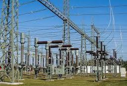
In Detail : The power distribution company in Noida has initiated a comprehensive GPS-based mapping exercise to digitally document its entire electricity network. The project will capture detailed geographic data of power infrastructure, including substations, transformers, feeders, panel boxes, and electric poles, creating a centralized digital map of the city’s distribution system.
The mapping exercise aims to enhance operational efficiency and improve fault detection across the network. Once completed, engineers will be able to identify the exact location of outages or technical issues in real time, enabling faster response and reducing downtime for consumers.
Officials indicated that the survey will cover more than 150 substations and over 24,000 transformers across Noida and adjoining areas. The infrastructure spread includes thousands of poles and distribution components across urban sectors and surrounding villages, all of which will be digitally mapped using GPS coordinates.
After mapping, each asset will be assigned a unique identification code linked to its geographical position. This will allow operators to monitor load levels, track supply routes, and assess performance of individual transformers and feeders through a centralized monitoring system.
The digital mapping will also help authorities detect overload conditions and potential equipment failures before they escalate. By analyzing load patterns and network stress, engineers can proactively upgrade infrastructure and prevent disruptions during peak demand periods.
Another major benefit of the initiative is improved monitoring of electricity theft and unauthorized connections. Any abnormal load increase in a mapped area will be visible to officials, allowing targeted inspections and better control over distribution losses.
The GPS-based system will provide real-time visualization of power infrastructure across nearly all sectors and villages in the district. This will allow field teams to quickly navigate to fault locations, reducing manual tracing time and improving maintenance efficiency.
The initiative also supports long-term modernization plans, including smart grid deployment and automation of power distribution. Digital mapping creates the foundation for advanced monitoring tools, remote switching, and predictive maintenance technologies.
Overall, the GPS mapping drive is expected to strengthen reliability of electricity supply in Noida. With a comprehensive digital database of assets, the discom aims to reduce outages, improve planning, and deliver faster service response as power demand continues to rise across the rapidly expanding city.
