

Aerial mapping of Bengaluru’s solar energy potential takes off


Bescom commissions initiative to meet the target of generation of 1,000 MW of rooftop solar energy by 2022 from Bengaluru alone
Laser mapping technology — where aerial light pulses are directed at the ground from an aircraft — recently helped archaeologists discover an ancient Mayan city under the jungles in Guatemala. In Bengaluru, the same technology — light detection and ranging (LiDAR) — is being used, but for a different reason.
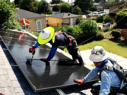
Over the fortnight, a helicopter armed with LiDAR system will fly across the city, mapping its potential to generate rooftop solar energy.
The initiative, which is based on a 2016 agreement of Bangalore Electricity Supply Company (Bescom) with the Centre for Study of Science, Technology and Policy (CSTEP) and Karnataka Renewable Energy Development Ltd. (KREDL), finally took flight on Sunday at Jakkur aerodrome.
Bescom has commissioned the mapping in a bid to meet its target of generation of 1,000 MW of rooftop solar energy by 2022 from Bengaluru alone.
The aircraft will cover an approximate area of 1,100 sq. km, generating high resolution images of rooftops of buildings in the city. The mapping will be carried out by CSTEP and the data generated will be submitted to the Energy Department.
The LiDAR technology will send pulsed laser light on to the rooftop of a building and translate the reflected light into data points. Based on objects such as trees surrounding the rooftop, shadow-free area available for solar power generation will be calculated and an estimate will be arrived at as to the capacity of solar generation of each building in the city, said officials.
The data mapping will continue for a fortnight for about two hours every day.
Saptak Ghosh, research scientist, CSTEP, said they had to take permission from six government departments and ensure that they were not capturing data of sensitive installations.
MoD to vet data
“Initially, we had proposed 1,100 sq. km to 1,200 sq. km. Around 100 sq. km of sensitive building were blotted out by the Ministry of Defence. As soon as we collect the data, we will send it to the MoD for vetting. We are likely to get back that vetted data in three months. Later, developing the tool based on this data will take another two months,” he said.
A senior official from the KREDL has been designated as the security officer to oversee that the aircraft flies only in permitted area.
What happens next
Once the data is collated and presented to the Energy Department, residents of the city will be able to check the capacity of solar power generation of the rooftops of their respective buildings, when they log in to the Bescom website to pay electricity bill. The system will send an OTP to the user to cross verify whether the particular rooftop belongs to the property owner.